Showing posts with label Mexico. Show all posts

Friday, December 25, 2015

Morning in Santa Rosalía

I spent last summer in Nopolo in Baja California Sur diving the islotes and headlands that I could reach with my kayak. I dove early in the morning, the coolest part of the day, and often saw the sunrise from the Transpeninsular Highway on my way to places where I could launch a boat. The Sea of Cortés was warm (low 80s°F) and gin-clear (visibilities greater than 40-50 ft). By mid-afternoon the heat was oppressive, weighing on me like a thick blanket; I spent them studying Spanish by the pool or visiting friends in homes where air conditioners and fans ran all day.
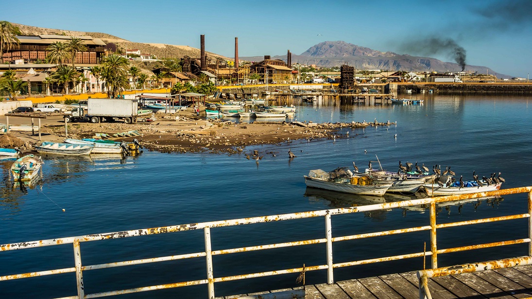
Santa Rosalía harbor with abandoned copper smelter (tall smokestacks)
Several divers told me that the best visibility in the Sea of Cortés occurred during the summer and I had to find out if that was true. The heat of Mexico in the summer was too much for Rande; she spent it at 7,000 feet in northern New Mexico looking for a place for us to live. We’ve been on the road since we sold our house in northern Colorado in 2013 and she was tired of living out of a truck always on the go. Near the end of the summer, with her father seriously ill, the plan was for me to return to New Mexico, meet Rande and drive us to Washington to be with her family.

Monday, November 16, 2015

Looking for Whales

Jacques Cousteau called the Sea of Cortés the “the aquarium of the world” (link), and you know it has to be a helluva big tank to hold 6,000 animal species – 4,854 invertebrates, 891 fishes, 181 birds, 36 mammals and seven reptiles (Brusca et al. 2005). We could discuss the “health” of the Sea of Cortés – the lack of freshwater flow and nutrients from the Colorado River; habitat destruction and bycatch by commercial shrimping; overfishing of sharks and groupers; over-harvesting of pearl oysters, sea turtles and whales; population crashes of the totuava (link) and vaquita (the world’s smallest and most endangered cetacean) and more (link, link). Maybe when I feel sufficiently misanthropic about the future of the “world’s aquarium,” I’ll depress you with some of those stories. For now I’d like to celebrate the remaining diversity in a diminishing sea.
Ron photographing humpback whale (Isla Danzante on the right)

Tuesday, October 20, 2015

San Cosme

Parque Nacional Bahía de Loreto is the largest marine park (800 square miles) on Mexico’s Pacific Coast. Park regulations prohibit spearfishing (except for subsistence by Mexicans), so I was looking places to launch my kayak outside the park. I plotted the park’s boundaries in Google Earth (they’re not shown on local maps) and looked for access roads. The first good access to the Sea of Cortés south of the park was San Cosme, 26 miles from Loreto. The 13-mile road from the Transpeninsular Highway to San Cosme reminded me of the road to Caleta Agua Armargosa in Gene Kira's King of the Moon: A Novel About Baja California:
…men fought their way from the main road in the west, over the high mountains, and down the very cliffs themselves, to the floor of the canyon. It was not a legitimate road they cut, but more of a plunging, twisting trail clinging to the sides of the cliffs. Is was so narrow in places one could not get out of a pickup, for on one side the door would be stopped by the face of the cliff, while on the other, it would open over noting but air.

Feral burros along the road to San Cosme

Tuesday, September 22, 2015

Cockfights in Loreto

I went to the cockfights in Loreto with Mark, a retired fireman from Anchorage. He was meeting Andrés, a friend and “roosterman” who was not fighting, but promised to show Mark around. Andrés said that he had 40-50 fighting roosters. He wasn't fighting because it was a championship and the biggest fight of the year in Loreto. Some of the teams were local and some roostermen brought birds from as far away as Constitución. There would be 100 fights and each team (a ranch or trainer) entered four birds. The fights began at 3 PM and would run until 3-4 AM the next morning. The top three teams would collect the prize money.


Warning: cockfighting is a blood sport; this post describes and has pictures of violence to animals.

Friday, August 21, 2015

Damselfish: Danger (and Sex) on the Reef

I was up before sunrise to go diving in Parque Nacional de Bahía Loreto (link). Driving south from Nopolo on Baja’s Transpeninsular Highway, I stopped at the Mirador (viewpoint) above the village of El Juncalito to check sea conditions. The winds were light from the north and the Sea of Cortés was calm. I turned off the highway where it turns inland and begins to climb. The dirt road to Ensenada Blanca drops down into an arroyo that drains a large canyon stirring up a cloud of dust. I wondered what the arroyo was like during a flash flood. 
Sunrise over Isla del Carmen from the Mirador above El Juncalito

Wednesday, July 15, 2015

Across the Sea of Cortés on Ferries

About a week before our six-month Mexican tourist visas expired, we drove up the east side of the Baja peninsula from Loreto to Santa Rosalía to catch the ferry to Guaymas on the mainland. We left late in the morning when the sun was high and the air was warm. It was Semana Santa (Easter Week) and we had been warned that the roads would be crowded with travelers. Mario, our neighbor just back from Mulege, told us that the beaches along the Sea of Cortés were packed with campers.
Playa El Requeson on Bahiá Concepcíon

Sunday, June 28, 2015

Beyond Puerto Vallarta

Rande and I spent two months around Bahía Banderas (Bay of Flags) on the Pacific Coast of Mexico. We stayed in Bucerias north of Puerto Vallarta, and Punta Negra and Boca de Tomatlán south of Puerto Vallarta. According to one writer, “…Banderas Bay seems to have been artfully designed for vacations and retirement. It seems to have been invented for people who believe they have suffered enough, so bring on the paradise, now, please…” (link).
The beach at Mismaloya
The high-rise hotels and elaborate tourist attractions of Puerto Vallarta and Nuevo Vallarta were less interesting to us than old town with its narrow streets, wonderful shops and restaurants, and assorted cast of locals, expatriates and tourists. We also explored several outlying areas and attractions including the set of The Night of the Iguana, a movie filmed at Mismaloya; the Vallarta Botanical Gardens; and the remote coast of Cabo Corrientes.

Tuesday, May 19, 2015

Losing Nemo

I was resting on the surface between dives when I was startled by a yellow flash in my peripheral vision. It was close to my mask and bright, taxi-cab yellow. I thought it was the sun reflecting off the yellow housing of the strobe attached to my camera and ignored it. I was freediving around one of the large rocks at Los Arcos south of Puerto Vallarta, exploring a series of ledges that stair-stepped down the wall. As I descended on my next dive, a yellow spot appeared in front of my mask. It was a small fish less than 5 cm (2 in) long, and it was leading me to the bottom.
Golden trevally swimming near my face

Saturday, April 25, 2015

Beach Life

The beach at La Manzanilla is a destination for gringos in the winter and for Mexicans in the summer.  This is not an upscale resort and the gringo visitors mostly come for a respite from their busy lives. They want to relax, to slow down, to experience their vision of a sleepy tropical village on the Pacific Ocean. One gringa travel writer wrote about returning to “…this dusty little Mexican fishing village, a hushed-up spot that's still off the clock and, for a while yet, off the tourist track…to settle back in my beachside chair and stare for hours at the mini-curl of surf, ice cubes melting in my Cuba Libre, skin glowing, mind blank, system on zero” (link).
Fishermen leaving the beach at La Manzanilla

Monday, March 23, 2015

The Crocodile Farm

According to the Ramsar Convention*, Bahía Tenacatita is one of the five most important bays on the Pacific Coast of Mexico. Estero La Manzanilla, an estuary on the east side of the bay, supports a mangrove forest in good condition. It is one of three estuaries on the coast with a large population of American crocodiles. During our stay in La Manzanilla, we often walked down a dirt road by the estuary to the restaurants on the beach. A sign said the area was a crocodile farm (cocodrilario) and a sagging chain-link fence was all that separated pedestrians from large crocodiles basking in the sunshine.
Be careful. Crocodiles in this area. Do not swim. Do not feed the crocodiles. Do not walk your pets. Do not fish. 

Saturday, February 28, 2015

Swimming in the Aquarium

The paved road to Tenacatita turns off Hwy 200 15 km (9 mi) northwest of La Manzanilla. I’m going to dive “The Aquarium,” a group of islotes (small islands) and submerged rocks on the north side of Bahía Tenacatita. The road winds through agricultural fields and two rural villages. Early in the morning when I pass through El Rabalsito, the larger village, shopkeepers are sweeping out their stores, dogs and chickens are foraging in the street and young and middle-aged men are waiting in the back of pickup trucks that will take them to work on local farms or into La Manzanilla and Melaque.
Farm on the way to Rabalsito

Saturday, January 24, 2015

La Manzanilla

La Manzanilla is a small village on the Pacific Coast north of Manzanillo in the state of Jalisco. We visited La Manzanilla while we were staying in Barra de Navidad and decided that we would return and stay for a month. There are no banks in the village and the only grocery stores are small tiendas. We drove 14 km (9 mi) south to Melaque, the largest community on the coast between Puerto Vallarta and Manzanillo, to do most of our shopping. 
Entrance to La Manzanilla
La Manzanilla’s main attractions are the beach, water sports (fishing, swimming, surfing, kayaking), RV camping, La Catalina Natural Language School (link) and crocodile reserve (hence the statue on the way into town). The place is not well known among gringos, but is a popular weekend and holiday destination with Mexicans.

Thursday, January 1, 2015

¡Feliz Año Nuevo!

Wishing you a happy New Year. If you've been following our blog, you may have noticed that we changed our picture and blog description. Last year when we began this enterprise, we were leaving the working world and transitioning into retirement. Once retired, we quickly realized how much we enjoyed it; the transition was not difficult.  “Every day’s a Saturday” as my former boss said after he retired.
Sunrise, Mar de Cortés
Traveling had a lot to do with easing the transition. We sold our house in northern Colorado, got rid of a lot of stuff, put the rest in storage, packed the truck and headed to Mexico. We loved northern Colorado, but didn't want to spend another winter there. We sold our snow shovels in a garage sale and gave our winter clothes to Goodwill.

Friday, November 21, 2014

Barra de Navidad

We left Ajijic early on a Sunday morning. Lake Chapala had been dry and dusty, although sprinkled a couple times hinting at the rainy season to come. We were heading back to the Pacific Coast where it would be warm and humid. Descending to the coastal plain from 1,525 m (5,000 ft) on the paved road from Guadalajara to Manzanillo, we could feel the temperature and humidity increasing to 25°C (77°F) and 70% humidity. The air felt dense and heavy. What would summer be like at 35°C (95°F) and 90% humidity? 
Marlin-sailfish sculpture at the entrance to Barra de Navidad
We spent five weeks on the Costa Alegre (happy or cheerful coast), roughly 300 km (180 mi) of coast south of Puerto Vallarta to Manzanillo. A tropical environment, modest beach towns and uncrowded beaches attract Mexicans on weekends and holidays from as far as Guadalajara and Mexico City (link). American and Canadian tourists and snowbirds show up in the winter (November-April) when the temperatures are warm and it rarely rains, but their presence is not large like in Puerto Vallarta.

Saturday, November 8, 2014

Hiking the Sierra Travesaño

Standing at 1,500 m (5,000 ft) in Ajijic looking up at the 2,500 m (8,000 ft) Sierra Travesaño made us want to put on our hiking shoes and find a trail. We found several hikes out of town in a guidebook by Teresa Kendrick (2007), including El Tepalo. Her directions were simple and straightforward – from Calle Jin (the main east-west street) follow Incarnación Rosas to Callejon de Tepalo up (north) to the entrance of El Tepalo – the canyon of the waterfalls. It was the end of the dry season, so we didn’t expect any water (and there wasn’t any). Our objective was the ridge where several white crosses were visible with binoculars from the village.
Looking up to the Sierra Travesaño

Tuesday, September 30, 2014

Tlaquepaque

Historically known as San Pedro, Tlaquepaque was eventually surrounded by Guadalajara as it grew and spread outwards. Now a city of about 600,000, Tlaquepaque is a few kilometers from the city center of Guadalajara. Tlaquepaque (pronounced tlah-kay-PAH-kay [link]) comes from the Nahuatl language and means “hill where the clay comes from” (link) referring to the city's long history of pottery making (link). We drove from Ajijic about an hour north to Tlaquepaque. We arrived before the shops opened, found parking and walked the streets photographing old buildings in the early light.
Ceramic pineapples for sale in Tlaquepaque

Friday, August 29, 2014

Guadalajara

Guadalajara is Mexico’s second largest city with a population over four million in the city and surrounding metropolitan area (link). It’s less than an hour’s drive from Lake Chapala. We took a bus from Ajijic ($50 MXN, about $4 USD) to avoid dealing with traffic and parking. The bus dropped us at the Antigua Central Camionera (old bus station*), which is more than a kilometer from the city’s Centro Histórico, the colonial center of the city, so we caught a taxi from the bus station.
Plaza Guadalajara looking toward the Palacio Municipal (built between 1949 and 1952)
The Centro Histórico is laid out like a cross from west to east when viewed from above (link). The cathedral lies at its crux surrounded by four plazas: Plaza Guadalajara at the head of the cross; Plaza de la Liberación at its base; Plaza de Armas to the south; and Plaza de la Rotonda to the north. The circular fountain in the Plaza Guadalajara is shaped like an oyster with rose petals alluding to the city's two nicknames: "Pearl of the West" and "City of Roses." The stairs lead to an underground parking garage.

Friday, July 25, 2014

Ajijic

We left the Pacific coast before Easter and headed inland to Lake Chapala. Semana Santa (Holy Week) was approaching and the beaches would be filled with vacationers, a kind of Mexican spring break. The drive from Barra de Navidad to Lake Chapala was uneventful. We took Mexico 200 south along the coast skirting mangrove-flanked estuaries and the port of Manzanillo. Turning north on Mexico 110, we passed through Colima, the capital of Mexico’s fourth smallest states, and picked up Mexico 54 to Guadalajara. Gaining elevation, we passed the impressive Colima Volcanic Complex, including Nevado de Colima at 4,300 m (14,000 ft), at the western end of the 900-km (560-mi) trans-Mexican volcanic belt (link).
Ajijic and Lago de Chapala

Friday, June 27, 2014

Los Toros y Las Sardinas

This is a story about life and death on a beach in Bahía de Banderas. The main characters are jurel toro, or simply toro, the local name for the Pacific crevalle jack (Carangidae), and sardina, the local name for the flatiron herring (Clupeidae). 
Jurel toro or Pacific crevalle jack
Sardina or flatiron herring

Sunday, June 15, 2014

Los Arcos

Los Arcos (The Arches) is one of the most popular diving and snorkeling spots in Bahía de Banderas (Bay of Flags) and is visited by many of the local tourist companies (link) and dive shops (link). It comprises five granite islets from 5-50 m (16-160 ft) high about 10 km (6 mi) south of Puerto Vallarta. I snorkeled the rocks when we were here in early April and again when we returned in early June.
Los Arcos from Puerto Vallarta