Showing posts with label Baja California Sur. Show all posts

Friday, December 25, 2015

Morning in Santa Rosalía

I spent last summer in Nopolo in Baja California Sur diving the islotes and headlands that I could reach with my kayak. I dove early in the morning, the coolest part of the day, and often saw the sunrise from the Transpeninsular Highway on my way to places where I could launch a boat. The Sea of Cortés was warm (low 80s°F) and gin-clear (visibilities greater than 40-50 ft). By mid-afternoon the heat was oppressive, weighing on me like a thick blanket; I spent them studying Spanish by the pool or visiting friends in homes where air conditioners and fans ran all day.
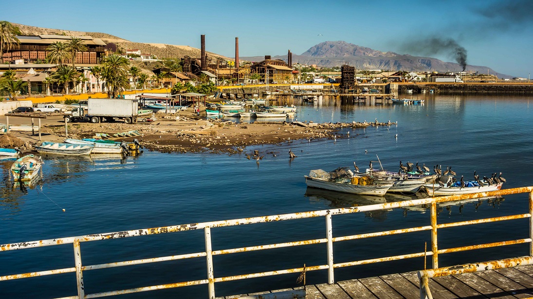
Santa Rosalía harbor with abandoned copper smelter (tall smokestacks)
Several divers told me that the best visibility in the Sea of Cortés occurred during the summer and I had to find out if that was true. The heat of Mexico in the summer was too much for Rande; she spent it at 7,000 feet in northern New Mexico looking for a place for us to live. We’ve been on the road since we sold our house in northern Colorado in 2013 and she was tired of living out of a truck always on the go. Near the end of the summer, with her father seriously ill, the plan was for me to return to New Mexico, meet Rande and drive us to Washington to be with her family.

Monday, November 16, 2015

Looking for Whales

Jacques Cousteau called the Sea of Cortés the “the aquarium of the world” (link), and you know it has to be a helluva big tank to hold 6,000 animal species – 4,854 invertebrates, 891 fishes, 181 birds, 36 mammals and seven reptiles (Brusca et al. 2005). We could discuss the “health” of the Sea of Cortés – the lack of freshwater flow and nutrients from the Colorado River; habitat destruction and bycatch by commercial shrimping; overfishing of sharks and groupers; over-harvesting of pearl oysters, sea turtles and whales; population crashes of the totuava (link) and vaquita (the world’s smallest and most endangered cetacean) and more (link, link). Maybe when I feel sufficiently misanthropic about the future of the “world’s aquarium,” I’ll depress you with some of those stories. For now I’d like to celebrate the remaining diversity in a diminishing sea.
Ron photographing humpback whale (Isla Danzante on the right)

Tuesday, October 20, 2015

San Cosme

Parque Nacional Bahía de Loreto is the largest marine park (800 square miles) on Mexico’s Pacific Coast. Park regulations prohibit spearfishing (except for subsistence by Mexicans), so I was looking places to launch my kayak outside the park. I plotted the park’s boundaries in Google Earth (they’re not shown on local maps) and looked for access roads. The first good access to the Sea of Cortés south of the park was San Cosme, 26 miles from Loreto. The 13-mile road from the Transpeninsular Highway to San Cosme reminded me of the road to Caleta Agua Armargosa in Gene Kira's King of the Moon: A Novel About Baja California:
…men fought their way from the main road in the west, over the high mountains, and down the very cliffs themselves, to the floor of the canyon. It was not a legitimate road they cut, but more of a plunging, twisting trail clinging to the sides of the cliffs. Is was so narrow in places one could not get out of a pickup, for on one side the door would be stopped by the face of the cliff, while on the other, it would open over noting but air.

Feral burros along the road to San Cosme

Tuesday, September 22, 2015

Cockfights in Loreto

I went to the cockfights in Loreto with Mark, a retired fireman from Anchorage. He was meeting Andrés, a friend and “roosterman” who was not fighting, but promised to show Mark around. Andrés said that he had 40-50 fighting roosters. He wasn't fighting because it was a championship and the biggest fight of the year in Loreto. Some of the teams were local and some roostermen brought birds from as far away as Constitución. There would be 100 fights and each team (a ranch or trainer) entered four birds. The fights began at 3 PM and would run until 3-4 AM the next morning. The top three teams would collect the prize money.


Warning: cockfighting is a blood sport; this post describes and has pictures of violence to animals.

Friday, August 21, 2015

Damselfish: Danger (and Sex) on the Reef

I was up before sunrise to go diving in Parque Nacional de Bahía Loreto (link). Driving south from Nopolo on Baja’s Transpeninsular Highway, I stopped at the Mirador (viewpoint) above the village of El Juncalito to check sea conditions. The winds were light from the north and the Sea of Cortés was calm. I turned off the highway where it turns inland and begins to climb. The dirt road to Ensenada Blanca drops down into an arroyo that drains a large canyon stirring up a cloud of dust. I wondered what the arroyo was like during a flash flood. 
Sunrise over Isla del Carmen from the Mirador above El Juncalito

Wednesday, July 15, 2015

Across the Sea of Cortés on Ferries

About a week before our six-month Mexican tourist visas expired, we drove up the east side of the Baja peninsula from Loreto to Santa Rosalía to catch the ferry to Guaymas on the mainland. We left late in the morning when the sun was high and the air was warm. It was Semana Santa (Easter Week) and we had been warned that the roads would be crowded with travelers. Mario, our neighbor just back from Mulege, told us that the beaches along the Sea of Cortés were packed with campers.
Playa El Requeson on Bahiá Concepcíon

Tuesday, May 19, 2015

Losing Nemo

I was resting on the surface between dives when I was startled by a yellow flash in my peripheral vision. It was close to my mask and bright, taxi-cab yellow. I thought it was the sun reflecting off the yellow housing of the strobe attached to my camera and ignored it. I was freediving around one of the large rocks at Los Arcos south of Puerto Vallarta, exploring a series of ledges that stair-stepped down the wall. As I descended on my next dive, a yellow spot appeared in front of my mask. It was a small fish less than 5 cm (2 in) long, and it was leading me to the bottom.
Golden trevally swimming near my face

Thursday, January 1, 2015

¡Feliz Año Nuevo!

Wishing you a happy New Year. If you've been following our blog, you may have noticed that we changed our picture and blog description. Last year when we began this enterprise, we were leaving the working world and transitioning into retirement. Once retired, we quickly realized how much we enjoyed it; the transition was not difficult.  “Every day’s a Saturday” as my former boss said after he retired.
Sunrise, Mar de Cortés
Traveling had a lot to do with easing the transition. We sold our house in northern Colorado, got rid of a lot of stuff, put the rest in storage, packed the truck and headed to Mexico. We loved northern Colorado, but didn't want to spend another winter there. We sold our snow shovels in a garage sale and gave our winter clothes to Goodwill.

Tuesday, February 18, 2014

Los Barriles

Los Barriles is a small town (pop. 1,174 in 2010 census) off the Transpeninsular Highway (KM 105) between La Paz and San José del Cabo. We drove by on a trip to Baja Sur in 2011, went back for two weeks in 2012 and for three months in 2013. Los Barriles translates as “the barrels”; according to legend, conquistadors buried gold in barrels in the hills overlooking Bahia de las Palmas (link)

The town grew up around sportfishing, which caught on in the 1950s and 1960s (link) when small fishing resorts hosted Hollywood stars like Errol Flynn, John Wayne and Bing Crosby (link). The area has some of the best fishing in the world (link, link, link) and fishing tournaments with significant prizes (link).
Entrance to Los Barriles from the Transpeninsular Highway
Today, snowbirds, part-time residents, retired gringos and tourists mingle with the local Mexican community. Cows and goats wander the roads and ATVs (known as “quads”) are a primary form of transportation. The main street through town is paved, but everything else is dirt. With only a few tourist hotels, Los Barriles is still a bit sleepy and dusty. It’s the anti-Cabo San Lucas – no cruise ships call here and the town is quiet after midnight.

Monday, February 10, 2014

The Muralist

A beat-up Ford Aerostar pulled up below the house and honked. A man in his 70s got out and started up the steep dirt driveway. “Hello” he called out without seeing anyone. I stuck my head over the second floor railing; “hola” I replied. He was tall and thin and wore a wide-brimmed straw hat, tan shorts and a well-worn, long-sleeve dress shirt buttoned in three places. He was clean shaven except for a neatly-trimmed pencil mustache and he leaned slightly forward as he climbed the rutted driveway confidently, if slowly, in his flip flops. “I’m David, John’s caretaker. I lived in this house until last week and I left a few things behind. Do you mind if I get them?”
David at the house of faces

Friday, January 17, 2014

Three Hikes

Baja has many opportunities for hiking – the challenge sometimes is finding them. If you have limited time, go with a guide (link); most tourist hotels can find one for you. This is a good plan for extended hikes because hiking trails can be confused with cattle trails. If you want to do it yourself, you can find trails on maps and blog posts and by word-of-mouth.

This post highlights three recent hikes. Hike #1 – Sol de Mayo – appears on low-resolution maps of the Sierra La Laguna Biosphere Reserve. The maps can’t be used for navigation. We learned about hike #2 – Arroyo Palmillas – on the Baja Pony Express (link), an English-language website with news, information and announcements for the gringo community. We learned about hike #3 – Sendero sin Nombre – by word of mouth.

Sol de Mayo

Located near the town of Santiago (KM 85 on the Transpeninsular Highway) on the east side of the Sierra La Laguna Biosphere Reserve, Cañon de la Zorra (Fox Canyon) is best known for its waterfall (cascada). Rancho Ecológico Sol de Mayo and has an entry fee of USD $6. Hike upstream from the waterfall (elevation about 275 m) and you'll find pools and wetlands and a beautiful canyon.
Entrance to Rancho Ecológico Sol de Mayo

Friday, December 20, 2013

El Tríunfo

Located at 1,700 ft (518 m) on the Transpeninsular Highway between La Paz and San Jose del Cabo, El Tríunfo (The Triumph) was a bustling mining town in the late 1800s and early 1900s. Today it is much smaller (pop. 327) and quieter, and many buildings are just brightly-painted brick facades. The mining-era ruins are extensive and well known, and include a smokestack designed by Gustave Eiffel. Tourists are also drawn to the “piano museum” and the Café El Tríunfo, owned by an ex-biker from California (his motorcycle is in the lobby).
The Transpeninsular Highway through El Tríunfo

Thursday, December 12, 2013

Descanso

Descanso is a place of rest, “a cross placed at the site of a violent, unexpected death, in memoriam" (link). Driving in Mexico you can't miss them – small (and not so small) homemade crosses, shrines and memorials to those killed in highway accidents. Roadside memorials are are often clustered around dangerous curves.
Dangerous curve on the Transpeninsular Highway
Roadside crosses belong to a long tradition of public memorialization of private grief (Everett 2002) and are found in many countries, including Chile, where they are known as animitas (link), Ireland (link), the U.S. Southwest (linkand Canada (Belshaw and Purvey 2009), but they are rooted in the Hispanic culture (link). During Spanish colonization of the Americas, people that died along the way were buried and the sites were marked with crosses sanctifying the ground. Descansos in New Mexico date back to the 1700s (Everett 2002).

Thursday, December 5, 2013

Houses in Gringolandia

November is the beginning of the return migration of Americans and Canadians to Gringolandia. Most spend the scorching Baja summer in other parts of North America and have second homes on the East Cape. The return of the gringos marks the start of the real estate season with for sale signs popping up all over the place. The houses are generally large and fully furnished; some even come with vehicles and other toys (ATVs, kayaks, etc.). This is largely a market for gringos.

Having bought, remodeled and sold a number of houses, Rande and I have an interest in real estate. And having discussed living outside the US, we've’ve visited several nearby open houses to learn about housing and the real estate market.

If you’re wondering what your dollars can buy in Mexico, here are some pictures from a lovely East Cape house on the Sea of Cortez that’s listed for US$1,100,000.

Thursday, November 21, 2013

Cañón de San Dionisio

The granite mountains of the Sierra la Laguna dominate the terrestrial horizon of the Cape Region in southern Baja. Running north-south about 100 km, they rise to over 2,100 m (7,000 ft) and cover 112,522 ha (278,000 ac). Access to the mountains is on dirt roads that follow river valleys and canyons from east to west on the Sea of Cortez side and west to east on the Pacific side. Trails over the high ridges begin where the roads end (link).
Looking down (east) Cañón San Dionisio
Rande and I drove up Cañón de San Dionisio from the town of Santiago on the east side of the mountains. The vegetation is arid scrub (“matorrales”) from sea level up to about 250 m (800 ft), dry forests up to 800 m (2,600 ft), evergreen oak woodlands (“encino”) up to 1,200 m (4,000 ft), oak-pine forests at the higher elevations and palm oases along the river channels (link). The variety of habitats and the area's isolation are reflected in its biodiversity – nearly 1,000 plant species have been recorded and 23% are endemics, including five endemic genera (link). Eight of the 42 species of reptiles and amphibians and eight of the 59 resident bird species are endemics (link).

Sunday, November 17, 2013

Beachcombing

Wikipedia defines beachcombing as “...an activity that consists of an individual ‘combing’ (or searching) the beach and the intertidal zone, looking for things of value, interest or utility.” Rande and I have combed the intertidal from the black beaches of Costa Rica to the green beaches of Hawaii looking for "things of interest." Now, with more free time and many miles of beaches nearby, we're working on proficiency. Our favorite beach is an uninhabited stretch of white sand south of Punta Arena on the Sea of Cortez. It’s great for seashells and glass.
Rande beachcombing near Punta Arena
Rande collects sea glass, but she’s also attracted to shells, rocks, wood and bones. Beachcombing to her is walking meditation; listening to the waves and the sound of her footsteps in the sand is a way to focus on the present (known as mindfulness). She may be onto something. Dr. Deacon Ritterbush (aka Dr. Beachcomb) describes beachcombing as “…an inexpensive way to achieve better mental, emotional and physical health; and a spiritual means to weather life’s challenges.”

Monday, October 28, 2013

Scorpions

We found the first scorpion in the house a few days after we arrived. I was in bed arranging books on the night table when I bumped the small, wooden lamp; a scorpion dashed out from beneath the base and disappeared over the back. I moved the night table, but the scorpion was gone. In the morning, we moved the furniture, but couldn't find it. A couple days later, Rande saw a scorpion on the wall in the bathroom similar to the one on the night table. I dispatched it with a fly swatter. Rande identified it on the Internet as a bark scorpion (Centruroides exilicauda). So far, we've found seven bark scorpions (five in the house) and two unidentified scorpions outside.
Bark scorpion about 2.5 inches total length on the wall in the living room
Unidentified scorpion about 3 inches total length outside the house

Thursday, October 24, 2013

Santuario de los Cactus

In 2011, Rande and I drove a rental car from Todos Santos on the Pacific side of southern Baja to Punta Colorado on the Sea of Cortez. Passing through the foothills of the Sierra de la Laguna, we saw a small sign pointing down a dirt road to the “Santuario de los Cactus.” We stopped for a short visit and returned to the cactus sanctuary this year.

El Santuario de los Cactus is 6 km off the Transpeninsular Highway between La Paz and San Jose del Cabo at about KM168. The 6-hectare (15-acre) forest-like sanctuary is surrounded by 50 hectares of protected land in ejido El Rosario, a small village of 25 families in the northern foothills of the Sierra de la Laguna [ejido is communally-owned farmland]. At an elevation of 425 m (1400 ft), the sanctuary is part of the dry forest ecoregion, the transition between the lowland xeric scrub of the southern Baja peninsula and the pine-oak forests of the mountains (link).

UNESCO designated the Sierra la Laguna a global biosphere reserve in 2003; 23% of the nearly 1,000 species found in the sierra are endemics. Human activities within the biosphere reserve include extraction of timber and other forest products, farming and cattle raising (link). 
Road to the cactus sanctuary with Sierra la Laguna in the background

Friday, October 18, 2013

Octave

While Colorado was bracing for snow, we experienced tropical storm (chubasco) Octave. Octave was a tropical depression on Saturday, October 12 and a tropical storm about 300 miles SSW of Baja the next day. By Monday (10/14), Octave was less than 200 miles from southern Baja with maximum sustained winds of 60 mph. NOAA’s National Hurricane Center predicted 3-6 inches of rain, storm surge with large waves and coastal flooding on the west side of the peninsula (www.nhc.noaa.gov). Octave made landfall Monday night (10/14) and early Tuesday (10/15). It was downgraded to a tropical depression as it passed over Baja north of us; by late Tuesday, it was a “remnant low” over mainland Mexico.
NASA Terra satellite image of Octave October 14 at 2:40 PM (NASA Goddard MODIS Rapid Response Team (www.nasa.gov)